See This Project | Similar Projects | All Projects for Client
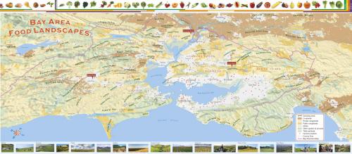
Where food comes from for residents of urban regions has become a major issue and has created great opportunities for farm-city relationships. GreenInfo was asked to prepare a large format fold out map of the food landscape of the San Francisco Bay region.
Developing the map of the Bay Area's broader food landscape took creative thinking - a satellite type view looking downwards lacked visual interest so GreenInfo's Louis Jaffe developed a side-looking view of the region, as if seen from an airplane over the ocean looking eastward back to San Francisco.
After wrestling with data on farming areas, Louis crafted a hillshade and color palette that would be easily readable in the 11"x33" fold out, and added featured areas referenced in the accompanying article. Bay Nature staff developed crop icons to adorn the final map.
Copies of this well-received map can be purchased from Bay Nature's online store >>
Focus: Environment
Services: GIS Services, Communications, Publications, Maps
Tags: agriculture, food, San Francisco Bay Area
Project Years: 2011