San Joaquin Valley Greenprint Pilot Project

Thematic poster
Client:   Sequoia Riverlands Trust

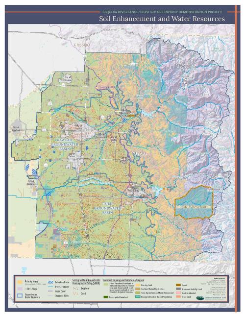
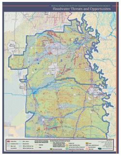
Whenever drought comes to California, we're reminded of the critical importance of groundwater to our farms and cities. New policies at the state level make it more likely than ever that we'll improve our groundwater management before the next drought comes. As part of a "Greenprint" project supported by the Fresno Council of Governments, GreenInfo worked with the Sequoia Riverlands Trust (SRT) to identify areas where groundwater enhancements projects are likely to be especially effective. 

Sequoia Riverlands Trust’s San Joaquin Valley Greenprint Demonstration Project explores the potential contribution of land-based strategies to watershed effectiveness, usable water supply and groundwater sustainability, focusing on three themes: 
  • Soil Enhancement and Water Resources
  • Floodwater Threats and Opportunities
  • Mineral and Water Resources
GreenInfo assisted with data gathering, analysis, print cartography (both poster and letter size), and web development. We did all data and cartography work using Esri ArcMap, and then developed the website using Postgres/PostGIS, Mapserver, Leaflet, and other open source tools.

Focus:   Conservation  

Services:  Interactive Solutions, GIS Services, Analysis, Data, Maps, Cartography, Web Mapping 

Tags:   Esri ArcGIS  

Project Years: 2016, 2017

GreenInfo Network creates, analyzes, visualizes and communicates information in the public interest. We specialize in mapping and related technology for nonprofits and public agencies, focusing on using it for conservation, social equity, public health, environment and foundation grant making.
2201 Broadway, Suite M5
Oakland
CA
94612
United States of America