See This Project | Similar Projects | All Projects for Client
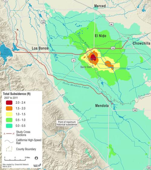
California's Central Valley faces severe problems due to declining groundwater, exacerbated by recent drought. The California Water Foundation developed a detailed analysis of issues and opportunities and asked GreenInfo to develop a key visual depiction of the groundwater data.
The California Water Foundation's mission is to sustainably meet California’s 21st century economic and ecological water needs, supporting a range of innovative projects and policy efforts. One of the key challenges being addressed by the foundation is groundwater management, particularly how to respond to severe overdrafting in California's Central Valley.
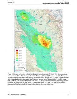
In developing a detailed report on the issue, prepared by the engineering firm of Luhdorff & Scalmanini, the foundation asked GreenInfo Network to create overview maps showing groundwater overdraft and land subsidence. GreenInfo worked closely with CWF and its engineering consultants to create a custom spatial database and to develop a set of images that clearly illustrate the location and depth of land subsidence in the San Joaquin Valley.
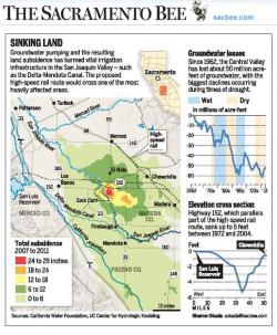
The Water Foundation's report was featured in an April 2014 Sacramento Bee article, which featured the mapping developed by GreenInfo Network.
Results: The project report and GreenInfo's mapping has been featured in various news accounts.
Focus: Environment
Services: GIS Services, Data, Maps
Tags: California, environment, Esri ArcGIS, groundwater, land subsidence
“ GreenInfo produced complex map products using data sourced from the Web and from space-based platforms. Their maps were the terrific and probably the most useful graphics in our 190-page report on Land Subsidence from Groundwater Use in California.”
— Jim Borchers, consulting hydrologist/hydrogeologist
Project Years: 2014