Similar Projects | All Projects for Client
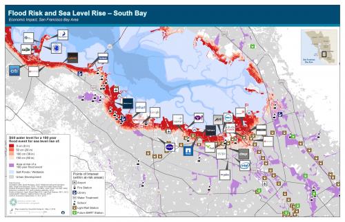
Climate change-driven sea level rise in the San Francisco Bay Area is a serious issue but one that has sometimes seemed distant from current business and governmental concerns. The Resources Legacy Fund asked GreenInfo to develop a map that would spark concern and engagement.
Using modeled sea level rise data from the USGS paired with headquarters locations for major businesses in the South Bay area, we created this map in an attempt to show the proximity of major corporations and areas threatened by future sea level rise. Our maps were featured in several press pieces, including Treehugger, ClimateWire, and Mercury News.
Focus: Economic Development, Environment
Services: GIS Services, Maps
Tags: climate change, Esri ArcGIS, San Francisco Bay Area, sea level rise
Project Years: 2012