Similar Projects | All Projects for Client
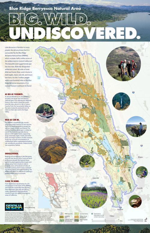
Away from the metropolis of the San Francisco Bay Area sits 800,000 acres of rugged wilderness, all within an hour's drive of seven million people. This poster was developed by GreenInfo to give strong identity to the region, as an aid to the public-private partnership promoting the area. Based on extensive GIS-driven science research, the poster distills key messages as a context for that biological and physical data.
The Blue Ridge Berryessa Natural Area (BRBNA) Conservation Partnership is a consortium of state, federal and local public agencies working cooperatively with nonprofit organizations to conserve and expand public recreational use of this 800,000 acre wilderness. In 2005-07, GreenInfo helped the Partnership develop display maps for some of its detailed scientific information and through that process encouraged them to create a lead map image that could help acquaint potential donors and other key players with the region, which is not well known. GreenInfo staff developed the overall message strategy in concert with BRBNA stakeholders and then prepared graphic concept poster mockups and cartographic alternatives to get basic directions set. Working with a graphic designer, the ArcGIS map elements were exported to Illustrator and the final composition was prepared. GreenInfo staff refined the GIS-based map which was adjusted in illustration software and placed in the production file. The map element was also placed into a brochure and other collateral information. The poster is printed at 13"x19" size.
Results: The poster is being used to support general outreach by the BRBNA Partnership.
Focus: Conservation
Services: GIS Services, Communications, Graphic Design, Maps, Cartography
Tags: Berryessa, Blue Ridge, Esri ArcGIS, map
Project Years: 2005-2007