GreenInfo Network is no stranger to supporting 30x30 work, so we were excited to work with Coastal Quest to support their 30x30 goal to strengthen water quality enforcement and management through gathering geospatial data for future use in data-driven decision making.
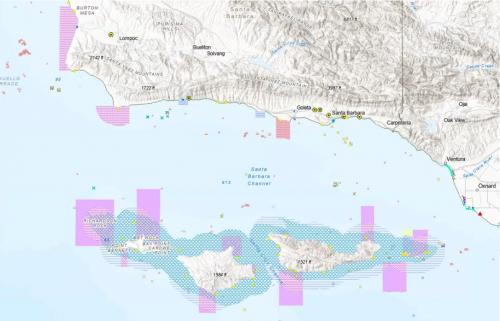
GreenInfo Network gathered coastal and marine data for Coastal Quest's pilot area - the California’s Central Coast - into an Esri geodatabase. While the pilot area was the Central Coast, we ultimately also gathered California-wide data for various datasets, as many datasets are published state-wide. We worked with Coastal Quest and the State Water Resource Control Board to narrow down what datasets were the most important for their geodatabase, and ultimately created an up-to-date and central data repository that will be immediately helpful for data analyses and data-driven decisions for the Marine Managed Areas in the pilot area.
Beyond the geodatabase build, we also documented the research, collection, and database creation process for Coastal Quest so that the collection of 30x30 relevant coastal and marine data can be expanded across the entire state of California.
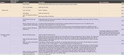
We used Google Sheets as an initial space for research and saving data sources. Google Sheets provides a space for iterative feedback and conversations, allowing live updates, as well as collaborative sharing of information.
We used Esri ArcPro to gather final datasets in a template so that the gathered data not only existed for analysis use in the database, but also could be visualized and shared in exported maps. In the template, we organized the data layers in categories (examples: Infrastructure, Managed Coastal Areas, Species). We also created a Metadata Library for Coastal Quest in Google Sheets, and organized the Data Library with the same grouping and layering order as the ArcPro file. The template also serves as a visual reference for analysts who need to determine what data layers to utilize for geospatial analyses, so this structure of the Data Library allows users looking at the ArcPro file to to easily find and review data sources and descriptions in the Data Library.
We made the ArcPro template cartographically-sound and ensured each data layer was well designed so that each data layer would be legible when a large number of data layers were turned on at the same time. The final geodatabase has more than 60 data layers – and not all data layers should be turned on at the same time – but maximizing the design for legibility helps ensure that complex data driven decisions can be made while using the template alone.
Focus: Conservation, Environment, Government Agencies
Services: GIS Services, Data, Maps, Cartography