Commodity production in tropical countries results in deforestation and contributes significantly to climate change. Earth Innovation Institute works to align sustainable supply-chain initiatives and finance (e.g. REDD) to support large-scale transitions to low carbon rural development, and asked GreenInfo to build a "Territorial Performance System" - an online mapping and monitoring platform that supports this initiative.
The
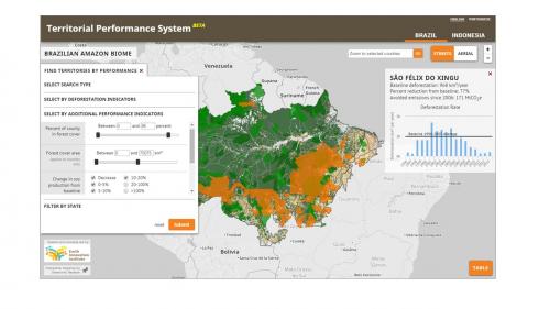
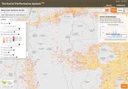
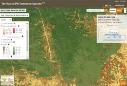
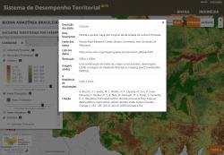
Territorial Performance System (TPS)
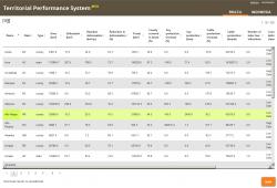
provides access to maps of forest cover, carbon, and statistics on deforestation to create a transparent platform to monitor and report on progress toward territorial sustainability goals. Working closely with
Earth Innovation Institute, GreenInfo built an online interface to allow users to quickly visualize and query this complex set of variables to find territories that meet thresholds of deforestation, forest cover and related measures.
The system avoids the high costs and complexity of farm-by-farm approaches and of tracing commodities from the property through supply chains. The platform can be used synergistically with farm-level certification and monitoring programs that are important mechanisms to promote and define sustainable production. TPS is designed to help government agencies and private industry, as well as support researchers, civic leaders and activists.
The application makes use of many open source mapping, visualization and spatial database tools, including Leaflet, PostGIS, DataTables and High Charts. We also built custom translation tools to allow users to asynchronously view the entire site in another language.
Currently, GreenInfo has built regional-level TPS applications for the Brazilian Amazon Biome, and Central Kalimantan (Indonesia). Plans are underway for similar TPS platforms in Peru, Columbia and Mexico (early 2015).
Results: By allowing civil society organizations, governments, commodity producers, and farmers to track sustainability targets, the Territorial Performance System helps EarthInnovation Institute in their mission to reduce tropical deforestation, stabilize the climate, and achieve achieve land, water and food security.
Focus: Conservation,
Economic Development,
Environment,
Government Agencies
Services: Interactive Solutions, GIS Services, Cartography, Applications Development, Web Mapping, Website Design
Tags: carbon,
climate change,
deforestation,
farming,
monitoring
Project Years: 2014-2015