Similar Projects | All Projects for Client
The gradual subdivision of rural land in California has profound implications for conservation, public safety, tourism and many other factors. GreenInfo undertook a first-ever assessment of the extent of rural land parcelization, supported by a grant from Wildspaces.
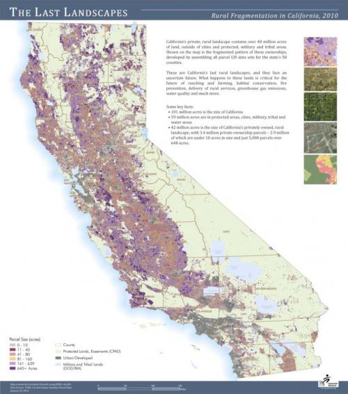
Outside of city boundaries and not including protected open space areas, California has 3.25 million parcels of privately owned land. In some areas, large ownerships still remain, but in much of the state property lines form a dense mesh, even if many of them are not yet built upon. The impacts of this parcelization can be dramatic - fire danger and the difficulty of trying to protect rural homes, barriers to critical habitat migration, increased public safety costs, degraded landscapes affecting tourism and more are all effects of lack of attention to rural land patterns in California.
GreenInfo's project involved developing a database of parcel boundaries for all counties in the state, selected a core of privately owned lands outside cities for further analysis and mapping. Assembling GIS data for over 55 California's counties (not including San Francisco), GreenInfo prepared a geodatabase of 3.25 million ownership parcels covering 40 million acres of the state's 100 million acres of land.
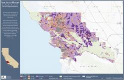
These lands were then stratified into size groupings, based on whether the parcels were on flat (mostly farmable) land, or whether they were in hilly areas - policy issues and development pressures are different for each of these landscape types. This analysis yielded an overall profile of fragmentation statewide and by county. Maps were then prepared of each county, creating an "atlas of fragmentation" for the state, as well as an overall state poster map.
One of the main findings of the study was the identification of the dozen "last landscapes", where there are still sizable areas of very large (over one square mile) parcels. There were relatively few of these, highlighting the need for protection efforts to consider these last, largely untouched landscapes. The study was not able to address the question of common ownerships, however, as data on who actually owns land in the state is very inconsistent and not always available with parcel GIS data.
To present this information, GreenInfo developed an entire website, "The Last Landscapes", which included an atlas of county parcelization maps, statewide maps and data and extensive information on parcelization background, effects and policy options.
Results: GreenInfo published the first-ever analysis of the fragmentation status of all private, non-urban land in California. This analysis shows that there are only a few "last landscapes" - areas that are largely intact and likely to be good candidates for conservation efforts.
Focus: Conservation
Services: GIS Services, Analysis, Data, Maps, Cartography
Tags: California, Esri ArcGIS, Last Landscapes, parcelization, parcels, subdivision
Project Years: 2009-2010