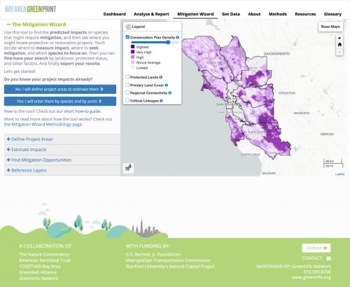
Every time a development or transportation project might have an impact on habitats or sensitive species, the people behind that project need to find mitigation opportunities to offset their impact. They could protect critical habitat or perhaps restore habitat nearby. Determining what species are affected, by how much, and where mitigation opportunities might be is no easy task, so it's often not tackled until late in the game. The Mitigation Wizard uses data developed by scientists at The Nature Conservancy and UC Davis to create an easy-to-use tool to quickly zero in on potential mitigation opportunities across the San Francisco Bay Area.
This idea for this project was born with The Nature Conservancy and Patrick Huber, from UC Davis, developed a region-wide assessment of mitigation potential for a few dozen listed species, as part of the Regional Advanced Mitigation Program. The goal of that work is to develop mitigation approaches where, instead of piecemeal mitigation one project at a time, a whole region has a shared set of goals and priorities, which should increase the overall positive impact of mitigation.
Huber produced a Marxan analysis to identify "hotspots" for species requiring mitigation. TNC Senior Scientist Carrie Schloss, who was part of the team (with us) who built
the Bay Area Greenprint, immediately saw the potential for using that dataset as the foundation for a new web application, part of the Greenprint, that could help planners across the region advance their projects while better protecting important habitats.
The tool takes a lot of complex data and filter and boils all that down to a simple workflow:
- Define project areas on a map
- Estimate impacts, with manual adjustments and per-species mitigation ratios
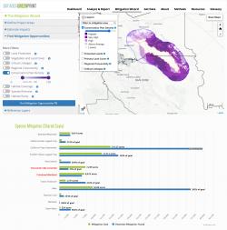
- Find mitigation opportunities, with a range of filters to allow you to zero in on the optimal locations
- Save, export, or share, your final mitigation zones, or directly load them in the Bay Area Greenprint for further mutlibenefit analysis.
Planners working in transportation, regional planning, conservation, and other fields can use the Mitigation Wizard as an early screening tool, including comparing potential project sites for differential impact, assessing a suite of multiple projects or even analyzing the mitigation potential of an entire watershed.
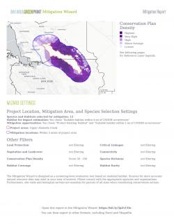
The tool offers complex spatial filtering by distance from project area, or containment within any combination of user selected shapes (eg, watersheds), user-drawn areas, or uploaded shapes. Mitigation opportunities are presented as a set of 25-acre hexagons that meet your search parameters. (Read more on
the Methodology page for how the tool works in detail.)
The application is built with Django, Postgres, and Mapserver on the backend, and AngularJS, Leaflet, Highcharts and other free or open source libraries on the frontend. Some of the more challenging filters, such as habitat coverage and species density, must be calculated on the fly based on the target species in your impact search. For these, we developed new methods of caching result sets and the calculating additional metrics against them, taking what could be extremely slow queries and getting them down to less than a minute.