Similar Projects | All Projects for Client
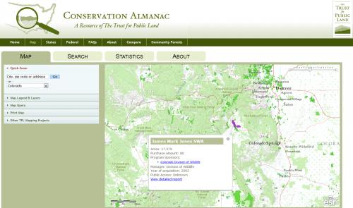
The Conservation Almanac is a project of The Trust for Public Land (TPL). The project grew out of the many requests The Trust for Public Land has received for data to understand the "context" for land conservation and the growing conservation finance movement. The site has profiles for each state, with downloadable PDFs describing TPL's work, and an interactive map to search for TPL projects.
The Trust For Public Land (TPL) Conservation Almanac makes it quick and easy to find what TPL is doing near you. The site's state profiles include downloads and maps showing TPL's land purchases and projects, and the interactive map provides simple but powerful searching tools down to a neighborhood level. Users may search for parcels purchased by specific funding programs, for parcels of a certain acreage, or by other criteria. Having found the information desired, users can download the data as spreadsheets, or as attractive PDF reports.
Results: The Almanac receives thousands of visitors per month, providing information on conserved lands and the funding which made them possible.
Focus: Conservation, Environment
Services: Interactive Solutions, Applications Development, Web Mapping
Tags: ArcGIS JavaScript API, conservation funding, PDF printing, TPL
Project Years: 2012
Documents: TPLParcelReport.pdf