See This Project | Similar Projects | All Projects for Client
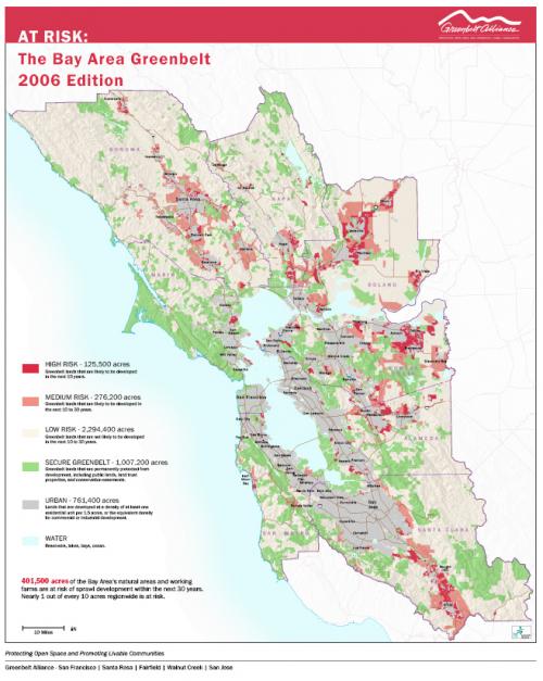
Protecting the rich open land resources of a major metropolitan region while also working to ensure smart urban growth is a big challenge. Greenbelt Alliance has partnered with GreenInfo Network to define the threats to both open space and sensible urban growth through its "At Risk" mapping project.
Defining the open lands of a major metropolitan region that are "at risk" of suburban development is a key strategy in both educating the public about these pressures, and posing the policy question, "do we need to have so much land slated for development?"
Greenbelt Alliance, the San Francisco Bay Area's land conservation and urban planning nonprofit has worked since the late 1980s to assess lands at risk and in 2004-2006 approached GreenInfo again to assist with a major update to this program. Greenbelt's risk mapping begins with assessing the prior risk designations, and updating urban development, city and protected area boundaries. Field staff then research each of the region's nine counties, looking at city and unincorporated plans, policies and politics, in order to define what lands are unprotected and proposed for near term or longer term development (the two main "risk" categories). Statistics are then compiled and assessed, and maps and reports developed. The risk reports typically get significant news media coverage.
For this round of "at risk", GreenInfo developed new data tracking systems to better assist the field staff, plus improved the GIS data that went into the base mapping. We then worked with Greenbelt staff to review likely areas for risk and developed final GIS mapping of these. Finally, we developed the publication display maps, including maps for a printed report, poster maps for events and conferences and digital images plus Google Earth files, for use by news media and others. A new round of risk mapping is being developed for publication in 2012.
Focus: Conservation, Environment
Services: GIS Services, Analysis, Data, Maps, Cartography
Tags: At Risk, California, Esri ArcGIS, GMAP, sprawl
Project Years: 2004, 2005, 2006