See This Project | Similar Projects | All Projects for Client
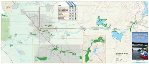
For years, the Tuolumne River Trust (TRT) has worked to improve appreciation of and support for the restoration of a section of the Tuolumne River that flows through California's Central Valley. The Trust asked GreenInfo to create a fold-up map flyer of key public access points along the river.
In the Central Valley, TRT is working to create a more a natural flood plain, a healthier river for people to enjoy and for fish to thrive in, and to restore streamside habitats for the wide variety of species that inhabit such river corridors. Key to their outreach is having maps that show people how to access the river.
The map developed by GreenInfo Network was done entirely in Esri ArcMap software, with a print-ready PDF created as output.
Focus: Environment
Services: GIS Services, Communications, Graphic Design, Publications, Maps
Tags: Access, Boating, Esri ArcGIS, Tuolumne River
Project Years: 2010