See This Project | Similar Projects | All Projects for Client
KCET television decided to feature a program on the use of park funds in the City of Los Angeles and asked GreenInfo to help it map data showing the disparities between where funds were generated and where they were used.
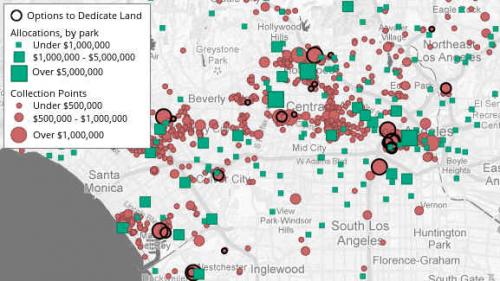
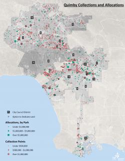
SoCal Connected filmed a second part of a television series on California's Quimby Act of 1965. The law was enacted to protect and create green spaces in urban areas -- developers of some types of residential buildings must either dedicate land or pay into a Quimby fund that is then to be used for the creation of green spaces in the same neighborhood.
GreenInfo developed an initial web map of city data showing projects that paid funds into Quimby accounts and where those funds were expended (more data is being sought). Over 40 properties were identified that could have been required to dedicate land (instead of money) and officials could not recall a single developer who had set aside land instead of paying a fee. With the acquisition of land being difficult, and likely more expensive, that means the City of Los Angeles will likely end up with less green space.
Results: GreenInfo developed for KCET TV a spatial database and a clean and simple web display for use in a television feature and by web site visitors.
Focus: Environment, Social Justice/Equity
Services: Interactive Solutions, GIS Services, Data, Maps, Web Mapping
Tags: Esri ArcGIS, Los Angeles, parks
Project Years: 2013