
See This Project | Similar Projects | All Projects for Client
A national inventory of all public parks and protected areas serves many different users. When the Centers for Disease Control and the National Park Service proposed to USGS - the manager of this data - that a policy paper and action agenda be developed to guide the future of this work, USGS asked GreenInfo to work with its PAD-US team to develop it. Over the course of a year, we created a highly detailed assessment and a three year action proposal, then developed several related publications and conducted a variety of presentations about the project.
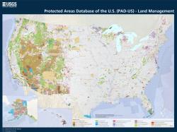
The Protected Areas Database of the United States (PAD-US) is the nation's official national inventory of all public parks and protected areas. GreenInfo has worked closely for many years with the USGS Gap Analysis Project PAD-US team and contributes our CPAD data to PAD-US. We also developed the www.ProtectedLands.net web site, which is a companion site to the official PAD-US website. This long experience and our extensive capacity in communications led USGS to ask us to take the lead on the project research and report preparation. The PAD-US team, part of the Great Basin Cooperative Ecosystem Studies Unit at Boise State University, worked alongside us on the project.
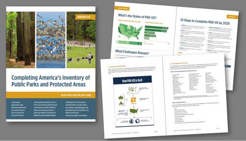
From late 2015 through 2016, we worked closely with a wide range of stakeholders to define key elements of the PAD-US strategy (particularly its relation to urban public parks), and to articulate them in plain language that would be accessible to a wide range of researchers, policy analysts, decision makers and others. Through review of reports, synthesis of PAD-US materials, surveys, and group discussions, we developed a detailed overall report and a shorter, graphical "prospectus" document.
The report describes the need for a national inventory, the nature of PAD-US and this type of geospatial data, the groups and agencies who are related to it, and a plan for moving forward to complete PAD-US and expand its use. Broadly, the report calls for three years of concentrated effort supported by a $7 million budget (of which about half is already available), focusing on continuing federal agency coordination, improving local and regional park lands data, strengthening PAD-US technical systems, and improving outreach and support.
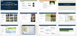
During this process, we also briefed the Federal Recreation Council (which also oversees Recreation.gov) on the PAD-US action plan at the Department of the Interior in Washington DC, and held a number of webinars with key groups. For these, we developed several versions of slide show to support short and longer presentations. We also developed a number of graphics illustrating key concepts in protected areas inventories (assisted by our longtime design partner, Ison Design).
The final reports are available as of December 2016 for download on the ProtectedLands.net web site. Limited copies are in print and can be requested from the PAD-US coordinator.
This work provides a new road map for PAD-US, taking the much earlier work we had done for PAD-US in 2009 and placing it in current time while also greatly expanding the information about PAD-US and the specifics of what is needed to complete and maintain this remarkable data set.
Focus: Conservation, Environment, Government Agencies, Human Services
Services: Communications, Graphic Design, Presentations, Strategy, Publications
Tags: PAD-US
“ I've watched this report evolve and it's exciting to see everything come together to convey this message so completely and concisely.”
— Roger M. Johnson, Chief Cartographer, National Park Service
“ Parks are a critical part of our country’s public infrastructure that can improve the health of individuals, families, and communities. But too often people do not know where they are. A validated, publicly available, national inventory of park locations can serve as a foundation for maps, mobile applications, research, park system plans… and the list goes on. This framework highlights that a national park inventory is both beneficial and doable.”
— Dee Merriam, FASLA, Community Planner, Centers for Disease Control and Prevention
Project Years: 2015-2016